
Search This Site


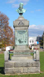
Governor Simon Snyder
Monument
Selinsgrove, PA
To access tombstone transcriptions for Snyder County, you must access two different sites:
| Adams Township | USGS 7.5' Map | GPS Coordinates |
|---|---|---|
| St. Peter's Independent Bible | Beavertown | 40:48:33 -77:11:32 |
| St. Peter's United Methodist | Beavertown | 40:48:17 -77:09:48 |
| Troxelville Union | Beavertown | 40:48:35 -77:11:53 |
| Troxelville (Saint James), moved to Union | Beavertown | N/A |
| Beaver Township | USGS 7.5' Map | GPS Coordinates |
| Beavertown God's Missionary | Beavertown | 40:46:46 -77:08:34 |
| Beavertown Borough | USGS 7.5' Map | GPS Coordinates |
| Beavertown (Cedar Hill) | Beavertown | 40:45:22 -77:10:18 |
| St. Paul's Union | Beavertown | 40:45:17 -77:10:17 |
| Center Township | USGS 7.5' Map | GPS Coordinates |
| Penns Creek Union (Emanuel Union) | Middleburg | 40:51:48 -77:03:13 |
| Saint Paul's United Methodist | Middleburg | 40:51:21 -77:03:42 |
| Salem United Methodist | Middleburg | 40:49:26 -77:03:09 |
| Sanders Family | Middleburg | |
| Zion United Methodist (Old); St. Luke's United Methodist (Kissimmee) | Middleburg | 40:48:34 -77:06:40 |
| Zion United Methodist (New) | Middleburg | 40:48:33 -77:06:37 |
| Chapman Township� | USGS 7.5' Map | GPS Coordinates |
| Botschaft's (Grubb's) Evangelical Lutheran | Dalmatia | 40:41:58 -76:56:55 |
| Chapman Chapel | Dalmatia | 40:42:08 -76:56:05 |
| Kramer Private | Dalmatia | 40:39:16 -76:55:30 |
| Paradise United Methodist | Dalmatia | 40:41:28 -76:55:53 |
| Rine Family | Dalmatia | 40:39:48 -76:55:52 |
| Sechrist Private | Dalmatia | 40:38:43 -76:56:16 |
| Saint John's (Chapman) United Methodist | Dalmatia | 40:41:10 -76:53:16 |
| Trinity United Brethren (extinct) | Dalmatia | 40:39:40 -76:55:23 |
| Zion (Hall's) Evangelical Lutheran | Dalmatia | 40:39:18 -76:55:52 |
| Franklin Township | USGS 7.5' Map | GPS Coordinates |
| Boyer Mennonite | Middleburg | 40:49:08 -77:01:02 |
| Christ (Hassinger Brick) Evangelical Lutheran | Middleburg | 40:47:06 -77:05:33 |
| Christ (Hassinger White) Evangelical Lutheran | Middleburg | 40:47:11 -77:05:13 |
| Hare-Walter Burial | Middleburg | not located |
| Hummel's United Methodist | Middleburg | 40:49:30 -77:00:32 |
| Kern Burials (Paxtonville School) | Middleburg | 40:45:59 -77:05:01 |
| Mertz Burial | Middleburg | 40:47:56 -77:00:58 |
| Paxtonville United Methodist | Middleburg | 40:46:04 -77:05:05 |
| Wayside Bible | Middleburg | 40:48:12 -77:01:58 |
| Freeburg Borough� | USGS 7.5' Map | GPS Coordinates |
| Evergreen | Freeburg | 40:45:57 -76:56:08 |
| Freeburg United Methodist (merged with St. Peter's Union) | Freeburg | N/A |
| Saint Peter's Union | Freeburg | 40:45:47 -76:56:32 |
| Jackson Township | USGS 7.5' Map | GPS Coordinates |
| Guier | Lewisburg | 40:53:03 -76:54:43 |
| Kratzerville Evangelical | Freeburg | 40:51:30 -76:53:30 |
| Templeton Private | Lewisburg | |
| Zion Union (Kratzerville) | Freeburg | 40:51:37 -76:53:45 |
| McClure Borough� | USGS 7.5' Map | GPS Coordinates |
| McClure Union | McClure | 40:42:30 -77:18:35 |
| Middleburg Borough | USGS 7.5' Map | GPS Coordinates |
| Glendale (Middleburg) | Middleburg | 40:47:39 -77:02:39 |
| Old Swineford, moved to Glendale | Middleburg | N/A |
| Middlecreek Township | USGS 7.5' Map | GPS Coordinates |
| Saint Peter's (Zieber's, Globe Mills) Union | Freeburg | 40:47:55 -76:59:13 |
| Saint Paul's (Erdley's) Union | Freeburg | 40:50:25 -76:58:32 |
| Smithgrove (Kreamer) | Freeburg | 40:48:14 -76:57:40 |
| Monroe Township | USGS 7.5' Map | GPS Coordinates |
| Hummels Family Cemetery | Sunbury | 40:50:10 -76:49:53 |
| Shreiner's Baptist (Evangelical) | Sunbury | 40:51:53 -76:50:34 |
| Penn Township� | USGS 7.5' Map | GPS Coordinates |
| Saint Paul's Evangelical Lutheran | Freeburg | 40:48:58 -76:52:48 |
| Salem (Rowe's) Union | Freeburg | 40:48:51 -76:54:12 |
| Perry Township | USGS 7.5' Map | GPS Coordinates |
| Amish Cemetery | ||
| Emanuel (Troutman's, Aline) United Methodist | Richfield | 40:40:46 -76:59:09 |
| Fairview | Richfield | 40:43:21 -77:00:51 |
| Oriental Church of the Brethren | Richfield | 40:38:31 -77:00:15 |
| Portzline Family | Dalmatia | 40:40:03 -76:59:10 |
| Saint John's (Schnee's) Union | Richfield | 40:43:35 -77:00:50 |
| Saint Thomas' United Methodist | Richfield | 40:40:04 -77:00:08 |
| Zion (Arbogast's) Union | Richfield | 40:40:46 -77:01:23 |
| Selinsgrove Borough | USGS 7.5' Map | GPS Coordinates |
| Evergreen (Baker's) | Sunbury | 40:47:43 -76:52:19 |
| Saint Paul's United Church of Christ (Reformed) | Sunbury | 40:48:18 -76:51:44 |
| Trinity (English, New) Lutheran | Sunbury | 40:48:11 -76:51:45 |
| Sharon (German) Evangelical Lutheran | Sunbury | 40:47:52 -76:51:48 |
| Wagenseller's Union | Freeburg | 40:47:52 -76:52:46 |
| Shamokin Dam Borough | USGS 7.5' Map | GPS Coordinates |
| Hartman's Family Cemetery | Sunbury | 40:50:32 -76:49:25 |
| Shamokin Dam | Sunbury | 40:51:00 -76:49:01 |
| Orchard Hills (West Side) | Sunbury | 40:51:20 -76:48:51 |
| Spring Township | USGS 7.5' Map | GPS Coordinates |
| Adamsburg | Beaver Springs | 40:44:46 -77:12:24 |
| Beaver Springs | Beaver Springs | 40:44:32 -77:12:22 |
| Manbeck's Evangelical United Brethren | Beavertown | 40:45:12 -77:14:24 |
| Union Township | USGS 7.5' Map | GPS Coordinates |
| Brubaker Private | Dalmatia | 40:41:39 -76:52:53 |
| Hoover Mennonite | 40:42:24 -76:53:53 | |
| Herrold Family | Dalmatia | 40:41:42 -76:52:43 |
| Saint Paul's (Keiser's, Fairview, Verdilla) Union | Dalmatia | 40:44:30 -76:54:19 |
| Stauffer's Mennonite | Dalmatia | 40:43:43 -76:52:13 |
| Susquehanna Mennonite | Dalmatia | 40:42:30 -76:54:09 |
| Witmer's (East) United Methodist | Pillow | 40:43:24 -76:52:21 |
| Witmer's (West) United Methodist | Pillow | 40:43:32 -76:54:11 |
| Mount Zion United Brethren | Pillow | 40:43:45 -76:52:08 |
| Washington Township | USGS 7.5' Map | GPS Coordinates |
| Bethel Mennonite | Dalmatia | 40:43:41 -76:58:47 |
| Ebenezer Bible | Dalmatia | 40:44:27 -76:57:25 |
| Fairview | Freeburg | 40:45:56 -76:56:35 |
| Freed Family Cemetery | Freeburg | not located |
| Zion (Morr's) Lutheran | Freeburg | 40:46:23 -76:56:47 |
| West Beaver Township | USGS 7.5' Map | GPS Coordinates |
| Baker's United Methodist | McClure | 40:44:03 -77:18:51 |
| Bannerville Church of the Brethren | McClure | 40:43:54 -77:20:58 |
| Saint John's (Black Oak Ridge) Evangelical Lutheran | McClure | 40:44:35 -77:17:44 |
| Saint Paul's (Black Oak Ridge II) Lutheran | McClure | 40:44:49 -77:17:16 |
| West Perry Township | USGS 7.5' Map | GPS Coordinates |
| Daniel's United Methodist | Richfield | 40:41:28 -77:03:19 |
| Graybill Mennonite | Richfield | 40:41:41 -77:06:32 |
| Pine Swamp Evangelical Methodist | Richfield | 40:41:08 -77:05:55 |